The Laugavegur is consistently ranked among the top long-distance treks in Europe and for good reason: within four days you cross rhyolite mountains in acid yellows and reds, descend through geothermal steam vents, traverse black sand deserts with no fixed reference point, ford glacial rivers that can reach your thighs, and arrive in the birch forest of Þórsmörk with a view of the Eyjafjallajökull glacier. The logistics are the hardest part.
Stage by Stage: Laugavegur Day Plan
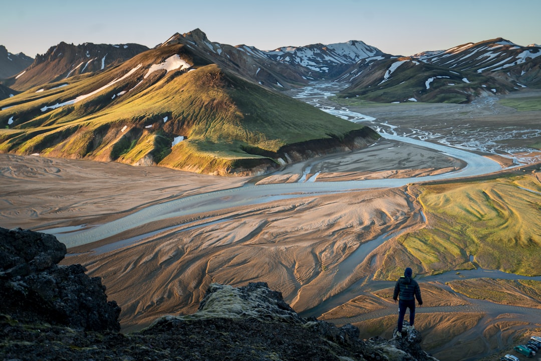
Day 1 — Landmannalaugar to Hrafntinnusker (12 km, 5–6 h)
The trail starts at the colourful Landmannalaugar campsite and climbing immediately into obsidian fields and fumaroles. The ridge above Brennisteinsalda (912 m) gives an early view of the rhyolite colour range. The Hrafntinnusker hut sits at 1100 m; it is cold and exposed — this is where unprepared hikers feel it first. Hot springs beside the hut are a comfort after a cold first day. Book the hut: fi.is → Hrafntinnusker.
Day 2 — Hrafntinnusker to Ãlftavatn (12 km, 4–5 h)
The descent from Hrafntinnusker passes a series of hot springs and snowfields (sometimes present into July). Ãlftavatn is a lake at 530 m; the hut sits right beside it. The change in landscape from the highland plateau to the green lake shore is dramatic. There is a small shop at the hut selling overpriced chocolate and instant noodles — buy it anyway.
Day 3 — Ãlftavatn to Emstrur/Botnar (15 km, 5–6 h)
The longest stage includes the two river crossings most people are anxious about. The Brenna and KaldakloftskvÃsl rivers require wading; in early season they can be thigh-deep. Unbuckle your pack hipbelt before you step in. Walking poles are genuinely useful here. The black sand desert of Mælifellssandur follows — disorienting on a foggy day, otherworldly on a clear one. The Emstrur hut is remote and wind-battered.
Day 4 — Emstrur to Þórsmörk (16 km, 5–6 h)
The final stage crosses a canyon lip with a view down to the Markarfljót river gorge, then descends through birch scrub into Þórsmörk valley. The Húsadalur campsite complex at Þórsmörk is the finish; there are hot showers, a restaurant and a bus service back to Reykjavik. Do not attempt to drive out — the Þórsmörk approach road crosses braided glacial rivers that swallow normal 4WDs.
How do I book the Laugavegur huts in 2025?
Huts are managed by Ferðafélag Ãslands (fi.is) and Útivist (utivist.is). Booking opens in October–November for the following summer. The trail fills to capacity; popular dates in July sell out within hours of booking opening. Create an account on fi.is in advance. You will need to book each hut individually: Hrafntinnusker, Ãlftavatn and Emstrur/Botnar for the standard 4-day route. Camping at the huts requires a separate camping ticket (cheaper but no indoor sleeping).
If huts are full, the Fimmvörðuháls trail (25 km from Þórsmörk to Skógar, passing two waterfalls and the 2010 eruption craters) can be walked independently as a day hike from the Þórsmörk end, or booked as an extension.
What is the best time to hike the Laugavegur?
The trail runs from late June to mid-September. Early July brings 24-hour daylight and snow on the high sections; late July is the peak for weather and crowds; August is slightly quieter with autumn colour beginning in Þórsmörk; September gives fewer people and moody light but snowfall is possible above 800 m. Avoid June if you are not comfortable wading high rivers — snowmelt is heaviest then. The trail is not maintained in winter and is genuinely dangerous outside the official season.
How do I get to Landmannalaugar from Reykjavik?
Reykjavik Excursions (re.is) and Trex (trex.is) both run scheduled highland buses from Reykjavik BSà terminal directly to Landmannalaugar from late June. Journey time is 4–5 hours including a rest stop. Book in advance; seats sell out. If you drive, a high-clearance 4WD is needed for the F-roads (the Landmannalaugar approach crosses a river). Do not attempt in a regular car. After the trek, buses from Þórsmörk to Reykjavik run daily in summer.
Laugavegur packing list — what you actually need
- Waterproof jacket and trousers — rain is certain on at least one day
- Insulated mid-layer (down or synthetic) — temperatures can drop to 0 °C overnight
- Gaiters — for river crossings and snow
- Waterproof hiking boots — trail runners become a problem at the river crossings
- Trekking poles — essential for river wading; useful on every descent
- Sleeping bag rated to −5 °C — hut duvets exist but are not guaranteed
- Headlamp — even in midsummer you may need it if weather delays you
- 4 days of food — the hut shops are minimal and expensive; cook your own or bring enough
- Water filter or iodine tablets — glacial streams are potable but a filter adds security near sheep pasture
- Sunscreen (unexpected but real: UV at altitude + snow reflection)
Total pack weight for a well-organised 4-day hut trip: 10–13 kg. Camping adds 3–5 kg for tent and extra food.
Is the Laugavegur suitable for beginners?
The Laugavegur is classed as moderate-to-strenuous. Navigation is straightforward in good visibility — the trail is marked with cairns and signposted at key junctions. The river crossings are the main objective hazard; they are manageable for most adults in normal season conditions but can be dangerous in high water or if you panic. If you have never done a multi-day mountain hike, do a two-day warm-up first — the West Highland Way or Tatra Mountains trek are good preparation. Fit beginners with a well-packed bag complete it without issue every year.
Looking for another northern European mountain route? Our Tatra Mountains 3-day trek guide covers a shorter alternative with hut booking included. For a broader overview of multi-day European routes, see the multi-day hikes in Europe pillar guide.