The GR20 (Grande Randée 20) is widely considered the toughest long-distance trail in Europe — and one of the most spectacular. Snaking along the granite spine of Corsica, it takes hikers through high-altitude passes, snowfields in early summer, maquis-scented scrubland and crystal-clear mountain lakes. If you are planning to walk the GR20 for the first time, this week-by-week guide covers everything you need to know about timing, accommodation, stages and logistics.
What to expect on the GR20: north vs south
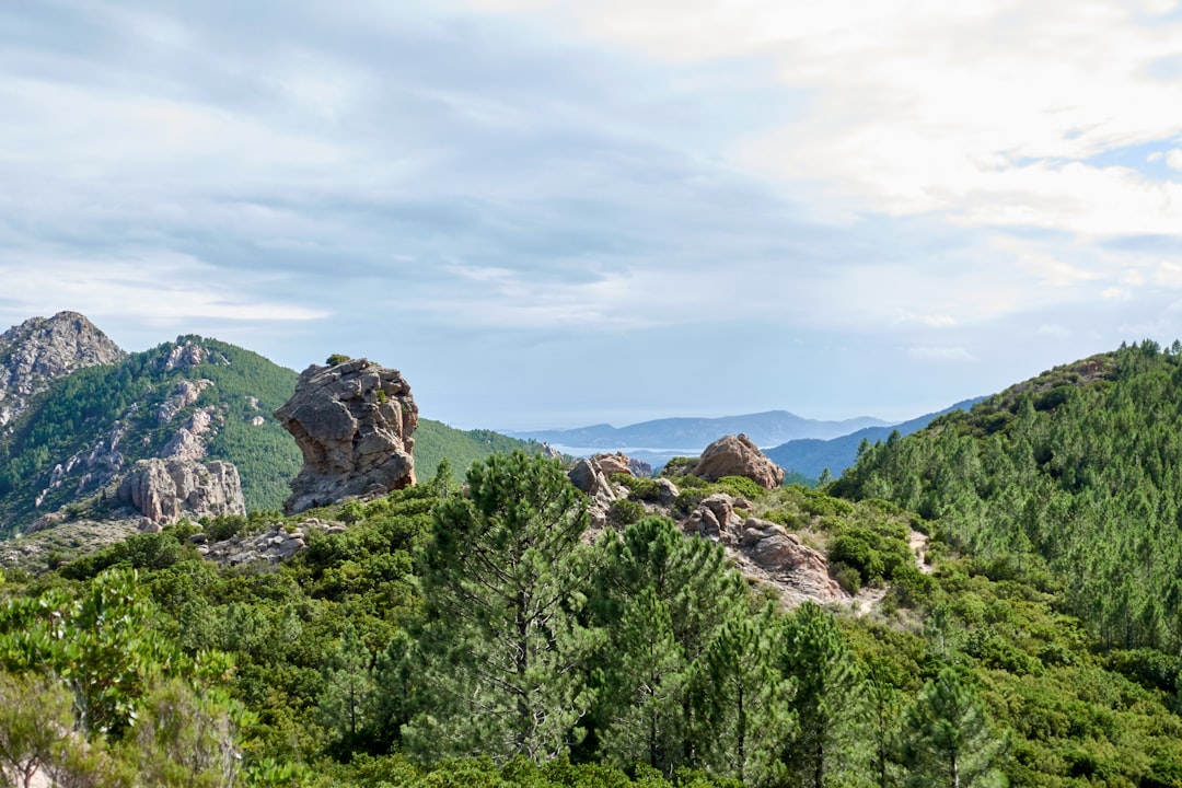
The GR20 is split into two distinct halves with very different characters. Understanding this division is essential for planning your hike.
The northern section (Calenzana to Vizzavona, ~97 km) is the harder half. Expect steep scrambles over granite boulders, exposed ridgelines above 2,000 metres and long days with 1,000+ metre elevation gains. Stages here take 6 to 9 hours and require sure footing and a head for heights. This is genuine mountain terrain, not a forest walk.
The southern section (Vizzavona to Conca, ~83 km) drops lower, passes through chestnut forests and Corsican villages, and is altogether more forgiving. Stages average 5 to 7 hours. Some hikers choose to walk only the south as a standalone trip if they are short on time or less experienced.
Week 1: Calenzana to Vizzavona (the technical north)
Start at Calenzana, a small village 10 km from Calvi in the north-west of the island. A shuttle bus runs from Calvi to Calenzana. The trailhead is clearly signed at the edge of the village.
Key stages in week one:
- Day 1 – Calenzana to Refuge d'Ortu di u Piobbu (6.5 hrs, +1,260 m). A brutal opener. Fill water at the fountain in Calenzana and pack suncream; the first few hours are exposed maquis with no shade.
- Day 2 – Ortu di u Piobbu to Refuge de Carozzu (6 hrs, +940 m). Technical sections with fixed chains over granite slabs near the Bocca Innominata pass.
- Day 3 – Carozzu to Refuge d'Asco Stagnu / Haut-Asco (3.5 hrs). Short day but tough terrain. The refuge at Haut-Asco has a small shop, showers and meals — stock up here for the next two hard days.
- Day 4 – Haut-Asco to Refuge de Tighiettu via Monte Cinto (7.5 hrs, +1,580 m). The highest point on the GR20 (Monte Cinto, 2,706 m). In June there may still be snow on this stage; bring microspikes if walking before mid-June.
- Day 5 – Tighiettu to Refuge de Ciottulu di i Mori (5.5 hrs). A scenic but tiring day crossing the Cirque de la Solitude alternative route. The original cirque route was permanently closed after a fatal rockfall in 2015; the bypass adds 1.5 hrs but is still genuinely challenging.
- Day 6 – Ciottulu di i Mori to Refuge de Petra Piana (6 hrs). The trail eases slightly. Arriving at Petra Piana in the afternoon gives you time to swim in the nearby lake — one of the highlights of the north.
- Day 7 – Petra Piana to Vizzavona (5–7 hrs). Most walkers stop at Refuge de l'Onda for the night; those with energy push on to Vizzavona where there is a train station, supermarket, hotel and restaurant. This is the most natural rest stop on the GR20.
Week 2: Vizzavona to Conca (the scenic south)
Vizzavona is a genuine resupply point. The small supermarket stocks dehydrated meals, snacks and gas canisters. The train from Ajaccio and Bastia stops here, making it easy to join the southern section without walking the north.
Key stages in week two:
- Day 8 – Vizzavona to Refuge de Capanelle (4.5 hrs, +880 m). An easier start for the south, through pine forests. The Capanelle refuge has a restaurant serving Corsican charcuterie and local cheese.
- Day 9 – Capanelle to Refuge de Prati (5 hrs). Open pastoral scenery, wild pigs and a long traverse with wide views towards the east coast.
- Day 10 – Prati to Refuge d'Usciolu (5.5 hrs). A beautiful ridge walk. From Usciolu you can see both coastlines of Corsica on a clear day.
- Day 11 – Usciolu to Cozzano (4.5–6 hrs). An optional detour to the village of Cozzano (20 min off-route) allows you to eat at a proper Corsican restaurant and sleep in a gîte. Strongly recommended after ten days of refuge food.
- Day 12 – Cozzano to Refuge de Palneca (5 hrs). Descends into chestnut groves and follows river valleys. Cooler and shadier than the north.
- Day 13 – Palneca to Refuge d'Asinau (7 hrs, +1,040 m). The Bavella needles (Aiguilles de Bavella) dominate the skyline and the terrain turns rocky. This is arguably the most photogenic section of the whole trail.
- Day 14 – Asinau to Refuge de Paliri (5 hrs). Long descent through pine and arbutus scrub. A final resupply point before the last push.
- Day 15 – Paliri to Conca (4.5 hrs). A gentle finale through maquis to the village of Conca. A local taxi service (book via the refuge the night before) runs to Porto-Vecchio, from where buses connect to Ajaccio or Bastia.
What is the best time to hike the GR20?
June and September are the sweet spots. In June the days are long, wildflowers are in bloom and the trails are not at peak capacity — though high passes may still hold snow, so check conditions before your start date. In September the temperatures drop, the crowds thin dramatically and the maquis turns golden. Avoid July and August unless you book refuges six or more weeks in advance; refuges fill completely, the heat on lower sections reaches 35°C and trail traffic is at its peak.
How do you book accommodation on the GR20?
The GR20 is serviced by a series of PNRC (Parc Naturel Régional de la Corse) refuges spaced one to two days apart. Each refuge offers dormitory sleeping (20–50 places), a tent area and meals (half-board around €45–55 per person). Book directly through the PNRC website or the individual refuge Facebook pages — many now take online reservations. Private gîtes and bergeries off-route accept walk-ins but fill fast in summer. Camping with a tent is allowed in designated areas around each refuge and is cheaper, but always carry a lightweight shelter regardless since weather can change rapidly.
What gear do you need for the GR20?
The GR20 demands proper mountain gear, not trail running shoes and a daypack. Non-negotiables include:
- Trekking poles — the granite slabs in the north are slippery, especially when wet or snowy
- Trail running shoes or lightweight hiking boots with ankle support
- A 35–45 litre pack (heavier packs become brutal on long climbing sections)
- Rain jacket and warm layer — temperatures above 2,000 m can drop below 5°C even in summer
- Headtorch, first-aid kit, water filter or purification tablets (streams are plentiful but refuge water is safe)
- Sunscreen and a hat — the high-altitude sun is fierce
Leave trekking sandals, cotton clothing and anything you do not use daily at home. Every gram counts after day five.
How difficult is the GR20 for beginners?
The GR20 is not a beginner trail. It is rated among the hardest long-distance routes in Europe. However, first-timers with a solid base of multi-day hiking experience — including at least a few trips with overnight packs — can complete it successfully. The key is preparation: walk with a loaded pack in the months before your trip, build up to 6–8 hour hiking days and research each stage in advance. Walking the southern section first (or only) is a sensible option if you are unsure about the north.
For more multi-day hiking inspiration in Europe, see our guides to the Iceland Laugavegur Trek and Faroe Islands hiking trails.
Planning more European adventures? See our complete guide to multi-day hikes in Europe for route recommendations across regions, hut booking tips, and gear advice.